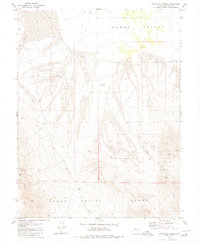
1980 Map of Poinsettia Spring
USGS Topo · Published 1980About this map
Gabbs Valley and the rising slopes of the Gabbs Valley Range define this high-desert landscape in Mineral County, Nevada. The mapping, based on 1970s aerial photography, captures a region shaped by scarce water and the search for minerals. The eponymous Poinsettia Spring is a vital water source near the Poinsettia Mine, while the whimsical label of the Car Frame Windmill indicates a localized landmark in the basin. Evidence of early resource exploration is scattered throughout the terrain, including a Prospect, a Dry Well, and the Gabbs Valley Ranch located to the northeast. Notable for genealogists and local historians is the isolated Grave recorded near the mine, a silent marker of the area's difficult working conditions. The terrain also features the stark Alkali Flat and the unique landmark known as Blue Sphinx.
Find a feature on this map
13 named features on this map. Tap any name to fly to it.
Don’t see what you’re looking for? This feature index may not catch every label — zoom into the map to look around manually.
Map Details
Editions of this 1980 Poinsettia Spring Map
This is the sole edition of this map. No revisions or reprints were ever made.
Other maps of this area

1909 · Hawthorne
USGS Topo · 1:250,000

1911 · Hawthorne
USGS Topo · 1:250,000

1915 · Hawthorne
USGS Topo · 1:250,000

1948 · Walker Lake
USGS Topo · 1:250,000

1957 · Walker Lake
USGS Topo · 1:250,000

1962 · Walker Lake
USGS Topo · 1:250,000

1964 · Walker Lake
USGS Topo · 1:250,000
1979 · Copper Mtn.
USGS Topo · 1:24,000
1979 · Ramsey Spring
USGS Topo · 1:24,000
1979 · Pilot Cone
USGS Topo · 1:24,000