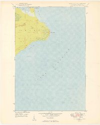
1949 Map of Point Isabelle
USGS Topo · Published 1949About this map
Mendota Light House stands as a sentinel at the narrow entrance to the Mendota Canal, a vital maritime passage connecting the sheltered waters of Lac La Belle to the expanse of Bete Grise Bay. This 1940s survey reveals the remote coastal character of Grant township on the Keweenaw Peninsula, where the landscape is defined by the reaching prominence of Point Isabelle. The shoreline topography demonstrates the importance of safe harbor along the Keweenaw's southern coast, with the canal serving as a critical link between inland waters and the depths of Lake Superior. South of the point, the curving reach of Oliver Bay completes a coastal sequence of bays and inlets that historically dictated navigation and settlement patterns in this northern Michigan wilderness.
Find a feature on this map
9 named features on this map. Tap any name to fly to it.
Don’t see what you’re looking for? This feature index may not catch every label — zoom into the map to look around manually.
Map Details
Editions of this 1949 Point Isabelle Map
This is the sole edition of this map. No revisions or reprints were ever made.
Other maps of this area

1927 · Point Isabelle
USGS Topo · 1:31,680

1938 · Delaware
USGS Topo · 1:31,680

1939 · Deer Lake
USGS Topo · 1:31,680

1939 · Delaware
USGS Topo · 1:31,680

1940 · Deer Lake
USGS Topo · 1:31,680

1940 · Fort Wilkins
USGS Topo · 1:31,680

1940 · Lake Medora
USGS Topo · 1:31,680
1948 · Delaware
USGS Topo · 1:24,000
1948 · Lake Medora
USGS Topo · 1:24,000

1948 · Fort Wilkins
USGS Topo · 1:24,000