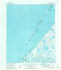
1955 Map of Point Lay D-2
USGS Topo · Published 1971About this map
Point Lay serves as the focal point of this coastal survey, situated on the narrow barrier strip separating the Kasegaluk Lagoon from the Chukchi Sea. The landscape is defined by the shifting interface of water and land, where the Kokolik River winds through a complex delta of marsh and tundra before emptying into the protected lagoon. Access to the open sea is maintained through Akunik Pass, a critical break in the sand-heavy barrier islands. A small Landing Strip south of the primary settlement reflects the importance of aerial transport in this isolated Arctic environment during the mid-1950s. The topography inland remains largely unsurveyed, marked by numerous small lakes and the drainages of Tungak Creek and Niklavik Cr near Tungaich Point. This map captures a snapshot of the region's geography before significant modern development reached the North Slope.
Find a feature on this map
10 named features on this map. Tap any name to fly to it.
Don’t see what you’re looking for? This feature index may not catch every label — zoom into the map to look around manually.
Map Details
Editions of this 1955 Point Lay D-2 Map
This is the sole edition of this map. No revisions or reprints were ever made.
Other maps of this area

1951 · Wainwright
USGS Topo · 1:250,000

1951 · Point Lay
USGS Topo · 1:250,000

1955 · Wainwright
USGS Topo · 1:250,000

1955 · Point Lay
USGS Topo · 1:250,000

1955 · Point Lay C-1
USGS Topo · 1:63,360
1955 · Wainwright A-6 and A-7
USGS Topo · 1:63,360
1955 · Point Lay D-1
USGS Topo · 1:63,360
1955 · Point Lay C-2
USGS Topo · 1:63,360

1964 · Wainwright
USGS Topo · 1:250,000

1965 · Point Lay
USGS Topo · 1:250,000