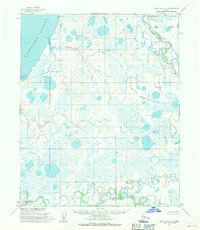
1955 Map of Point Lay D-1
USGS Topo · Published 1971About this map
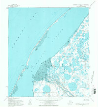
Kasegaluk Lagoon and the coastal barrier of the North Slope dominate this 1955 topographic study. The landscape is defined by the winding paths of the Utukok River in the northeast and the Kokolik River in the south, both of which demonstrate the dramatic meandering patterns typical of Arctic coastal plains. Between these major arteries, the terrain is a complex network of thaw lakes and smaller drainages like Kugachiak Creek and Tungak Creek. This map, based on aerial photography from the mid-1950s, documents the undisturbed hydrology of the region before significant modern development. The absence of roads or permanent structures across this vast expanse of tundra highlights the isolation of this corner of Alaska, where the natural movement of water across sand bars and through permafrost-driven lake systems remains the primary architectural force of the land.
Find a feature on this map
6 named features on this map. Tap any name to fly to it.
Don’t see what you’re looking for? This feature index may not catch every label — zoom into the map to look around manually.
Map Details
Editions of this 1955 Point Lay D-1 Map
2 editions found
Other maps of this area

1951 · Utukok River
USGS Topo · 1:250,000

1951 · Wainwright
USGS Topo · 1:250,000

1951 · Point Lay
USGS Topo · 1:250,000

1955 · Wainwright
USGS Topo · 1:250,000

1955 · Point Lay
USGS Topo · 1:250,000
1955 · Utukok River C-5
USGS Topo · 1:63,360

1955 · Point Lay C-1
USGS Topo · 1:63,360
1955 · Utukok River D-5
USGS Topo · 1:63,360
1955 · Wainwright A-6 and A-7
USGS Topo · 1:63,360
1955 · Point Lay D-2
USGS Topo · 1:63,360