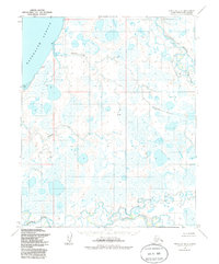
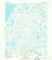
1955 Map of Point Lay D-1
USGS Topo · Published 1986About this map
Kasegaluk Lagoon defines the northwestern coastal edge of this remote Arctic landscape, where the tides of the Chukchi Sea meet a complex network of tundra waterways. Inland from the barrier-guarded lagoon, the terrain is dominated by the meandering paths of the Utukok River and the Kokolik River, which wind through a mosaic of wetlands and seasonal drainages. The 1955 aerial photography captures a wilderness largely devoid of permanent settlement, though a solitary Drill Hole in the central interior suggests the early stages of industrial exploration on the North Slope. Smaller drainages like Kugachiak Creek and Tungak Creek further partition the landscape, illustrating the saturated, low-lying character of the region. This survey, later updated in 1985, serves as a record of the area's hydrology and landforms before the further expansion of modern infrastructure in the Alaskan north.
Find a feature on this map
6 named features on this map. Tap any name to fly to it.
Don’t see what you’re looking for? This feature index may not catch every label — zoom into the map to look around manually.
Map Details
Editions of this 1955 Point Lay D-1 Map
2 editions found
Other maps of this area

1951 · Utukok River
USGS Topo · 1:250,000

1951 · Wainwright
USGS Topo · 1:250,000

1951 · Point Lay
USGS Topo · 1:250,000

1955 · Wainwright
USGS Topo · 1:250,000

1955 · Point Lay
USGS Topo · 1:250,000
1955 · Utukok River C-5
USGS Topo · 1:63,360

1955 · Point Lay C-1
USGS Topo · 1:63,360
1955 · Utukok River D-5
USGS Topo · 1:63,360
1955 · Wainwright A-6 and A-7
USGS Topo · 1:63,360
1955 · Point Lay D-1
USGS Topo · 1:63,360