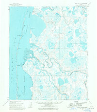
1955 Map of Point Lay C-2
USGS Topo · Published 1971About this map
Kasegaluk Lagoon dominates this coastal landscape along the Chukchi Sea, where the waters of the Kukpowruk River and Epizetka River meet the Arctic coast. This mid-century survey captures a series of small, isolated outposts including Elmer, Garner, and Brant situated along the riverbanks and coastal bluffs. The presence of a Cem near the river fork and a Quonset Hut on the barrier island reflects the sparse but intentional human footprint in this remote region. Farther north, the Kokolik R feeds into the lagoon near a Landing Strip and Tower Dome, marking essential infrastructure for northern transport and communication during the 1950s. The map illustrates a complex network of mud flats and tidal passes, notably Kukpowruk Pass, which define the shifting boundary between the tundra and the sea.
Find a feature on this map
18 named features on this map. Tap any name to fly to it.
Don’t see what you’re looking for? This feature index may not catch every label — zoom into the map to look around manually.
Map Details
Editions of this 1955 Point Lay C-2 Map
This is the sole edition of this map. No revisions or reprints were ever made.
Other maps of this area

1951 · Point Lay
USGS Topo · 1:250,000

1955 · Point Lay
USGS Topo · 1:250,000

1955 · Point Lay B-1
USGS Topo · 1:63,360

1955 · Point Lay C-1
USGS Topo · 1:63,360
1955 · Point Lay B-2 & 3
USGS Topo · 1:63,360
1955 · Point Lay D-1
USGS Topo · 1:63,360
1955 · Point Lay D-2
USGS Topo · 1:63,360

1965 · Point Lay
USGS Topo · 1:250,000
2014 · Point Lay B-2 NE
USGS Topo · 1:25,000
2014 · Point Lay C-2 NW
USGS Topo · 1:25,000