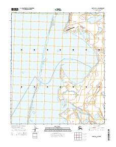
2014 Map of Point Lay C-2 NW
USGS Topo · Published 2014About this map
Point Lay occupies a narrow strip of land overlooking the expansive Kasegaluk Lagoon in this Arctic coastal landscape. The settlement is defined by a modest grid of thoroughfares including Qasigialik Street and Tutunniaqvik Street, which connect to the Airport Road leading south to the Point Lay LRRS Airport. This infrastructure highlights the isolation and logistical challenges of the North Slope, where air travel is a primary link to the outside world.
Find a feature on this map
19 named features on this map. Tap any name to fly to it.
Don’t see what you’re looking for? This feature index may not catch every label — zoom into the map to look around manually.
Map Details
Editions of this 2014 Point Lay C-2 NW Map
This is the sole edition of this map. No revisions or reprints were ever made.
Other maps of this area

1951 · Point Lay
USGS Topo · 1:250,000

1955 · Point Lay
USGS Topo · 1:250,000
1955 · Point Lay D-2
USGS Topo · 1:63,360
1955 · Point Lay C-2
USGS Topo · 1:63,360

1965 · Point Lay
USGS Topo · 1:250,000
2014 · Point Lay D-2 SW
USGS Topo · 1:25,000
2014 · Point Lay C-2 NE
USGS Topo · 1:25,000
2014 · Point Lay C-2 SE
USGS Topo · 1:25,000
2014 · Point Lay C-2 SW
USGS Topo · 1:25,000
2014 · Point Lay D-2 SE
USGS Topo · 1:25,000