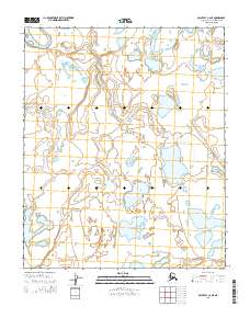
2014 Map of Point Lay C-2 NE
USGS Topo · Published 2014About this map
Kokolik River winds through the northwestern corner of this remote North Slope landscape, which is defined by a dense network of thaw lakes and arctic wetlands. This 2014 survey captures a vast area of the North Slope Borough, Alaska, where water dominates the geography through interconnected basins and subtle drainage patterns like Niklavik Cr. The lack of man-made structures or roads in these townships, including t4n r44w and t5n r44w, reflects the pristine and uninhabited character of the coastal plain environment. Researchers and geologists can study the natural hydrography and the shifting boundaries of permafrost-affected water bodies that characterize this part of the Alaskan wilderness.
Find a feature on this map
8 named features on this map. Tap any name to fly to it.
Don’t see what you’re looking for? This feature index may not catch every label — zoom into the map to look around manually.
Map Details
Editions of this 2014 Point Lay C-2 NE Map
This is the sole edition of this map. No revisions or reprints were ever made.
Other maps of this area

1951 · Point Lay
USGS Topo · 1:250,000

1955 · Point Lay
USGS Topo · 1:250,000

1955 · Point Lay C-1
USGS Topo · 1:63,360
1955 · Point Lay D-1
USGS Topo · 1:63,360
1955 · Point Lay D-2
USGS Topo · 1:63,360
1955 · Point Lay C-2
USGS Topo · 1:63,360

1965 · Point Lay
USGS Topo · 1:250,000
2014 · Point Lay C-2 NW
USGS Topo · 1:25,000
2014 · Point Lay D-2 SW
USGS Topo · 1:25,000
2014 · Point Lay D-1 SW
USGS Topo · 1:25,000