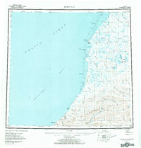
1955 Map of Point Lay
USGS Topo · Published 1971About this map
Point Lay serves as the primary outpost on this coastal stretch of the North Slope, situated on a narrow spit between Kasegaluk Lagoon and the Chukchi Sea. The 1955 survey illustrates the isolation of the settlement, supported by a Landing Area and the Point Lay Aerodrome. Inland, the landscape is defined by a network of braided rivers including the Kokolik River, Kukpowruk River, and Utukok River, which flow from the southern Amatusuk Hills toward the coast. A notable Winter Trail parallels the shoreline, providing a vital overland connection through this Arctic environment. For genealogists and local historians, the presence of a Cem near the village and scattered Cabin sites along the coast offers evidence of early twentieth-century habitation and land use patterns before modern infrastructure reached this part of the Arctic coast.
Find a feature on this map
37 named features on this map. Tap any name to fly to it.
Don’t see what you’re looking for? This feature index may not catch every label — zoom into the map to look around manually.
Map Details
Editions of this 1955 Point Lay Map
3 editions found
Other maps of this area

1951 · De Long Mountains
USGS Topo · 1:250,000

1951 · Utukok River
USGS Topo · 1:250,000

1951 · Wainwright
USGS Topo · 1:250,000

1951 · Point Lay
USGS Topo · 1:250,000

1951 · Misheguk Mountain
USGS Topo · 1:250,000

1952 · Point Hope
USGS Topo · 1:250,000

1952 · Point Hope D-1
USGS Topo · 1:63,360

1955 · Wainwright
USGS Topo · 1:250,000

1955 · De Long Mountains
USGS Topo · 1:250,000

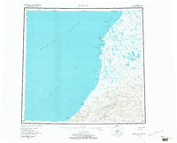
1955 · Point Lay
USGS Topo · 1:250,000