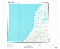
1955 Map of Point Lay
USGS Topo · Published 1971About this map
Point Lay sits on the edge of the Chukchi Sea, serving as a critical threshold between the mainland and the expansive Kasegaluk Lagoon. This mid-century survey illustrates a landscape dominated by complex hydrological networks, where the Kokolik River and Kukpowruk River meander toward the coast through numerous passes like Akunik Pass and Kukpowruk Pass. The isolation of the settlement is reinforced by the presence of the Point Lay Airstrip and Point Lay Landing Area, which provided essential links for the village. To the south, the topography transitions into the Amatusuk Hills and Kiklupiklak Hills, bordering the Beaufort Basin. Researchers will find localized details such as a Cem near the village and the coastal prominence of Cape Beaufort, marking the southern boundary of this remote Arctic coastal environment.
Find a feature on this map
36 named features on this map. Tap any name to fly to it.
Don’t see what you’re looking for? This feature index may not catch every label — zoom into the map to look around manually.
Map Details
Editions of this 1955 Point Lay Map
3 editions found
Other maps of this area

1951 · De Long Mountains
USGS Topo · 1:250,000

1951 · Utukok River
USGS Topo · 1:250,000

1951 · Wainwright
USGS Topo · 1:250,000

1951 · Point Lay
USGS Topo · 1:250,000

1951 · Misheguk Mountain
USGS Topo · 1:250,000

1952 · Point Hope
USGS Topo · 1:250,000

1952 · Point Hope D-1
USGS Topo · 1:63,360

1955 · Wainwright
USGS Topo · 1:250,000

1955 · De Long Mountains
USGS Topo · 1:250,000

1955 · Point Lay
USGS Topo · 1:250,000