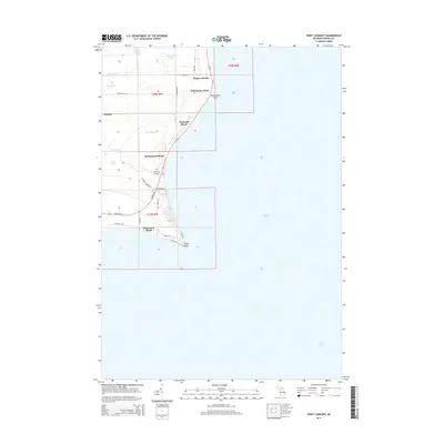
2014 Map of Point Lookout
USGS Topo · Published 2014About this map
Point Lookout and the surrounding shoreline of Saginaw Bay define this 2014 geographic study of the Whitney Township coast. The landscape is characterized by a series of beach communities and seasonal settlements, including Glenwood Beach, Birchwood Shores, Hammell Beach, and Wagner Beach, all linked by the corridor of Us-23. Inland, the terrain is shaped by a network of drainage features like Dime Drain, Red Drain, and Silver Drain which manage the low-lying areas near Oxbow Lake and Cranberry Lake. Genealogists and local historians will find the placement of Whitney Sims Cem and Sims Cem particularly useful for tracing family roots in this corner of Arenac County. The map also captures the transition from the marshy interior to the prominent coastal landmarks of Whitestone Point and the sharp peninsula at the southern end of the sheet.
Find a feature on this map
38 named features on this map. Tap any name to fly to it.
Don’t see what you’re looking for? This feature index may not catch every label — zoom into the map to look around manually.
Map Details
Editions of this 2014 Point Lookout Map
This is the sole edition of this map. No revisions or reprints were ever made.
Other maps of this area

1954 · Flint
USGS Topo · 1:250,000

1954 · Tawas City
USGS Topo · 1:250,000

1958 · Flint
USGS Topo · 1:250,000

1958 · Tawas City
USGS Topo · 1:250,000

1966 · Point Lookout
USGS Topo · 1:24,000

1966 · Au Gres
USGS Topo · 1:24,000

1966 · Alabaster
USGS Topo · 1:24,000

1966 · National City
USGS Topo · 1:24,000

1970 · Sand Point
USGS Topo · 1:24,000
1970 · Charity Island
USGS Topo · 1:24,000