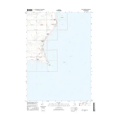
2017 Map of Point Lookout
USGS Topo · Published 2017About this map
Wagner Beach and the neighboring shoreline communities of Whitestone Point and Hammell Beach sit along the western edge of Saginaw Bay, where Michigan's Arenac County meets Lake Huron. The landscape is defined by the transition from low-lying interior wetlands and drainage systems like Silver Drain and Dime Drain to the sandy points and bluffs of the coast. Local family names and community history are preserved in the naming of features such as Hammell Cr and the Whitney Sims Cem, which lies just inland from Birchwood Shores. At the southern end of this coastal stretch, Point Lookout marks a distinct geographic turn in the shoreline near Glenwood Beach. The map details a network of residential lake roads, including E Point Lookout Rd and N Huron Rd, illustrating the developed recreational and residential character of this Lake Huron frontage.
Find a feature on this map
47 named features on this map. Tap any name to fly to it.
Don’t see what you’re looking for? This feature index may not catch every label — zoom into the map to look around manually.
Map Details
Editions of this 2017 Point Lookout Map
This is the sole edition of this map. No revisions or reprints were ever made.
Other maps of this area

1954 · Flint
USGS Topo · 1:250,000

1954 · Tawas City
USGS Topo · 1:250,000

1958 · Flint
USGS Topo · 1:250,000

1958 · Tawas City
USGS Topo · 1:250,000

1966 · Point Lookout
USGS Topo · 1:24,000

1966 · Au Gres
USGS Topo · 1:24,000

1966 · Alabaster
USGS Topo · 1:24,000

1966 · National City
USGS Topo · 1:24,000

1970 · Sand Point
USGS Topo · 1:24,000
1970 · Charity Island
USGS Topo · 1:24,000