
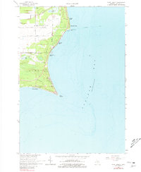
1966 Map of Point Lookout
USGS Topo · Published 1968About this map
Point Lookout juts sharply into the waters of Saginaw Bay, defining the coastal character of this 1966 survey. The shoreline is a dense patchwork of seasonal and permanent settlements, including Birchwood Shores, Glenwood Beach, and Hammell Beach. Inland, the landscape transitions to the rural townships of Whitney and Sims, where small agricultural tracts are accessed by local routes like Whitman Road and Bessinger Road.
Find a feature on this map
28 named features on this map. Tap any name to fly to it.
Don’t see what you’re looking for? This feature index may not catch every label — zoom into the map to look around manually.
Map Details
Editions of this 1966 Point Lookout Map
2 editions found
Other maps of this area

1954 · Flint
USGS Topo · 1:250,000

1954 · Tawas City
USGS Topo · 1:250,000

1958 · Flint
USGS Topo · 1:250,000

1958 · Tawas City
USGS Topo · 1:250,000

1966 · Au Gres
USGS Topo · 1:24,000

1966 · Alabaster
USGS Topo · 1:24,000

1966 · National City
USGS Topo · 1:24,000

1970 · Sand Point
USGS Topo · 1:24,000
1970 · Charity Island
USGS Topo · 1:24,000

1984 · Tawas City
USGS Topo · 1:100,000