
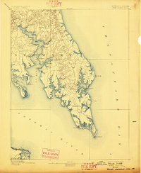
1894 Map of Point Lookout
USGS Topo · Published 1894About this map
The southern tip of the St. Mary peninsula is recorded here as it appeared in the late 19th century, dominated by a maritime economy of wharves and coastal landings. Strategic water access is evident at Bacon Wharf, Jones Wharf, and Benville Wharf, which served as vital connections for agricultural and tobacco transit before modern road networks. Inland, the settlement patterns of Great Mills and Park Hall are clearly established, while the lower neck includes Ridge (Friendship) and Scotland leading toward the terminal point at Point Lookout. The landscape is deeply incised by tidal reaches such as the St. Mary River and St. George Creek, which isolate landmasses like St. George Island. Topographer A.E. Murlin surveyed this area in 1890, capturing the intricate shoreline of Cornfield Harbor and the numerous named points that guided Chesapeake navigation.
Find a feature on this map
56 named features on this map. Tap any name to fly to it.
Don’t see what you’re looking for? This feature index may not catch every label — zoom into the map to look around manually.
Map Details
Editions of this 1894 Point Lookout Map
2 editions found
Other maps of this area

1892 · Leonardtown
USGS Topo · 1:62,500

1892 · Drum Point
USGS Topo · 1:62,500

1892 · Piney Point
USGS Topo · 1:62,500

1894 · Piney Point
USGS Topo · 1:62,500

1895 · Leonardtown
USGS Topo · 1:62,500

1895 · Nomini
USGS Topo · 1:125,000

1895 · Piney Point
USGS Topo · 1:62,500

1898 · Nomini
USGS Topo · 1:125,000

1898 · St. Marys
USGS Topo · 1:125,000

1901 · Drum Point
USGS Topo · 1:62,500