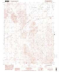
1984 Map of Point of Rocks
USGS Topo · Published 1984About this map
Nevada Test Site boundaries dominate the northeastern portion of this mid-1980s landscape, marking a restricted zone of significant cold-war era activity. The terrain is defined by the meeting of the Specter Range and the northern reaches of the Spring Mountains, with the prominent outcrop known as Point of Rocks situated centrally along the valley floor. Transportation is limited to a few arterial routes, most notably 95 and the Mercury Highway, which provide access through the arid Mercury Valley. Factual markers of infrastructure include the Natl Weather Station and Army Well No 1, reflecting the region's managed environmental and military utility. Scattered Prospects and a Borrow Pit suggest small-scale extractive attempts within the vast basins between these major mountain blocks.
Find a feature on this map
12 named features on this map. Tap any name to fly to it.
Don’t see what you’re looking for? This feature index may not catch every label — zoom into the map to look around manually.
Map Details
Editions of this 1984 Point of Rocks Map
2 editions found
Other maps of this area

1907 · Las Vegas
USGS Topo · 1:250,000

1908 · Furnace Creek
USGS Topo · 1:250,000

1908 · Las Vegas
USGS Topo · 1:250,000

1910 · Furnace Creek
USGS Topo · 1:250,000

1942 · Indian Spring
USGS Topo · 1:125,000

1942 · Skull Mountain
USGS Topo · 1:125,000

1948 · Death Valley
USGS Topo · 1:250,000

1952 · Specter Range
USGS Topo · 1:62,500

1952 · Mercury
USGS Topo · 1:62,500

1954 · Las Vegas
USGS Topo · 1:250,000