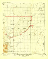
1916 Map of Point Of Sands
USGS Topo · Published 1946About this map
The White Sands dune field dominates this landscape, defined by the early boundaries of the White Sands National Monument and the expansive Lake Lucero to the west. Surveyed between 1912 and 1915, the map captures a network of family-owned ranching operations that once ringed the dunes, including Bairds Ranch, McNew Ranch, and Pelman Ranch. These cattle and goat operations relied on scattered water sources like San Nicolas Spring and Salt Spring at the edge of the San Andres Mountains.
Find a feature on this map
25 named features on this map. Tap any name to fly to it.
Don’t see what you’re looking for? This feature index may not catch every label — zoom into the map to look around manually.
Map Details
Editions of this 1916 Point Of Sands Map
2 editions found
Other maps of this area

1891 · Las Cruces
USGS Topo · 1:125,000

1893 · Las Cruces
USGS Topo · 1:125,000

1916 · Tonuco
USGS Topo · 1:125,000

1916 · Salinas Peak
USGS Topo · 1:125,000

1916 · Tularosa
USGS Topo · 1:125,000

1916 · Point Of Sands
USGS Topo · 1:125,000

1932 · Tonuco
USGS Topo · 1:125,000

1940 · Orogrande
USGS Topo · 1:62,500

1941 · Organ Peak
USGS Topo · 1:62,500

1943 · Parker Lake
USGS Topo · 1:62,500