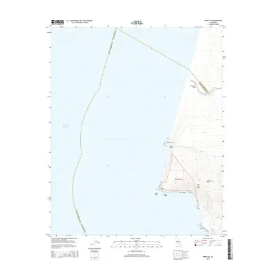
2015 Map of Point Sal
USGS Topo · Published 2015About this map
Point Sal anchors this coastal survey, where the terrestrial terrain of the Casmalia Hills meets the Pacific Ocean. The geography is defined by a series of prominent headlands and offshore features, including Mussel Point, Mussel Rock, and the twin formations of Lion Rock and Seal Rock. Inland, the Point Sal Ridge rises above the coastline, accessible by the winding Point Sal Rd. To the north, the Santa Maria River terminates its course through the Santa Maria Valley, marking the boundary between Santa Barbara and San Luis Obispo counties. The map provides a look at this preserved shoreline as it appeared in 2015, showing the complex topography of the coastal bluffs and the Public Land Survey System divisions in t10n r36w.
Find a feature on this map
14 named features on this map. Tap any name to fly to it.
Don’t see what you’re looking for? This feature index may not catch every label — zoom into the map to look around manually.
Map Details
Editions of this 2015 Point Sal Map
This is the sole edition of this map. No revisions or reprints were ever made.
Other maps of this area

1897 · Port Harford
USGS Topo · 1:62,500

1897 · Arroyo Grande
USGS Topo · 1:62,500

1900 · San Luis
USGS Topo · 1:125,000

1905 · Guadalupe
USGS Topo · 1:125,000

1941 · Port San Luis
USGS Topo · 1:62,500

1942 · Guadalupe
USGS Topo · 1:125,000

1942 · Arroyo Grande
USGS Topo · 1:62,500

1942 · Point Sal
USGS Topo · 1:62,500
1945 · Port San Luis
USGS Topo · 1:62,500
1947 · Casmalia
USGS Topo · 1:24,000