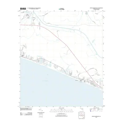
2012 Map of Point Washington
USGS Topo · Published 2012About this map
The Intracoastal Waterway cuts through this coastal stretch of Walton County, separating the inland settlement of Point Washington and the hamlet of Choctaw from the developing beach communities along the Gulf. On the southern coast, a sequence of planned communities and vacation destinations has emerged, including Seagrove Beach, Seacrest, and Rosemary Beach. The landscape is defined by its coastal dune lakes, such as Eastern Lake, Deer Lake, and Camp Creek Lake, which sit just inland from the Gulf of Mexico. These rare freshwater systems and the surrounding marshy tributaries like Peach Creek and Roaring Creek illustrate the intersection of Florida's waterway infrastructure with its shoreline residential growth. Further east, the map traces the transition toward Powell Lake and the newer developments of Alys Beach and Inlet Beach near the county line.
Find a feature on this map
65 named features on this map. Tap any name to fly to it.
Don’t see what you’re looking for? This feature index may not catch every label — zoom into the map to look around manually.
Map Details
Editions of this 2012 Point Washington Map
This is the sole edition of this map. No revisions or reprints were ever made.
Other maps of this area

1936 · Point Washington
USGS Topo · 1:48,000

1939 · Point Washington
USGS Topo · 1:62,500

1943 · Laguna Beach
USGS Topo · 1:31,680

1943 · Seminole Hills
USGS Topo · 1:24,000

1944 · Seminole Hills
USGS Topo · 1:31,680

1944 · Bruce
USGS Topo · 1:24,000

1945 · Bruce
USGS Topo · 1:31,680

1954 · Tallahassee
USGS Topo · 1:250,000

1957 · Pensacola
USGS Topo · 1:250,000

1959 · Tallahassee
USGS Topo · 1:250,000