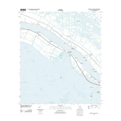
2012 Map of Pointe a la Hache
USGS Topo · Published 2012About this map
Pointe à la Hache and its surrounding riverbank settlements define this 2012 landscape along the Mississippi River in Plaquemines Parish. The map reveals a high concentration of family and community burial sites, including Nero Cem, Woodland Cem, and Saint Paulinus Cem, which serve as vital markers for local genealogists. Industrial activity is prominent through numerous revetments and energy sites like the Pointe A La Hache Oil and Gas Field and Magnolia Oil and Gas Field. Beyond the levee, a complex network of waterways including Back Levee Canal, Bayou Grande, and Grand Bayou segments the low-lying terrain. Smaller hamlets like Barthelemy Settlement, Bohemian, and Beshel are connected by narrow lanes and river-paralleling roads, reflecting a settlement pattern strictly dictated by the delta's hydrology.
Find a feature on this map
67 named features on this map. Tap any name to fly to it.
Don’t see what you’re looking for? This feature index may not catch every label — zoom into the map to look around manually.
Map Details
Editions of this 2012 Pointe a la Hache Map
This is the sole edition of this map. No revisions or reprints were ever made.
Other maps of this area

1891 · Pointe a La Hache
USGS Topo · 1:62,500

1892 · Quarantine
USGS Topo · 1:62,500

1892 · Pointe a La Hache
USGS Topo · 1:62,500

1893 · Fort Livingston
USGS Topo · 1:62,500

1893 · Dime
USGS Topo · 1:62,500

1935 · Port Sulphur
USGS Topo · 1:31,680

1935 · Lake Batola
USGS Topo · 1:31,680

1935 · Wilkinson Bay
USGS Topo · 1:31,680

1939 · Pointe a La Hache
USGS Topo · 1:62,500

1941 · Black Bay
USGS Topo · 1:62,500