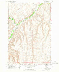
1965 Map of Poisel Butte NW
USGS Topo · Published 1966About this map
Satus Creek and Logy Creek converge in this high-desert landscape of Yakima County, defining a topography of steep draws and prominent ridges. The 1965 field check reveals a sparse settlement pattern dominated by grazing and tribal lands, anchored by the enigmatic Wasteland location and several established Corral sites along the watercourses. The presence of the Menninick Cem and Smina Cem provides specific genealogical touchpoints for the Yakama Reservation area, while the network of unpaved routes like Dry Creek Road and Pine Springs Road illustrates the era's reliance on rugged access trails. Rising above the valley, Poisel Butte serves as the dominant landmark, overlooking a terrain punctuated by isolated water sources such as Seep and Spring.
Find a feature on this map
17 named features on this map. Tap any name to fly to it.
Don’t see what you’re looking for? This feature index may not catch every label — zoom into the map to look around manually.
Map Details
Editions of this 1965 Poisel Butte NW Map
This is the sole edition of this map. No revisions or reprints were ever made.
Other maps of this area

1910 · Zillah
USGS Topo · 1:125,000

1937 · White Swan
USGS Topo · 1:125,000

1950 · Yakima
USGS Topo · 1:250,000

1958 · Hembre Mtn
USGS Topo · 1:24,000

1958 · Toppenish SW
USGS Topo · 1:24,000

1958 · Harrah SE
USGS Topo · 1:24,000

1958 · Yakima
USGS Topo · 1:250,000

1961 · Yakima
USGS Topo · 1:250,000
1965 · Kusshi Creek
USGS Topo · 1:24,000
1965 · Logy Creek
USGS Topo · 1:62,500