
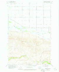
1958 Map of Toppenish SW
USGS Topo · Published 1960About this map
Toppenish Ridge dominates the center of this landscape, creating a sharp topographical divide between the irrigated lowlands and the canyons to the south. In the late 1950s, this area of Yakima County shows an intensive water management system on the valley floor, defined by the Marion Drain, various levees, and straight-line roads such as Yost Road and Ashue Road. These engineered features contrast sharply with the wandering path of Toppenish Creek and its tributary, Snake Creek. South of the ridge, the terrain breaks into complex drainages including Dry Creek and Satus Creek. A notable landmark, Hole in the Wall, sits at a gap in the ridge, while a Gaging Station and Cemetery near the southern boundary provide specific points of interest for local history and genealogical research.
Find a feature on this map
25 named features on this map. Tap any name to fly to it.
Don’t see what you’re looking for? This feature index may not catch every label — zoom into the map to look around manually.
Map Details
Editions of this 1958 Toppenish SW Map
2 editions found
Other maps of this area

1910 · Zillah
USGS Topo · 1:125,000

1937 · White Swan
USGS Topo · 1:125,000

1950 · Yakima
USGS Topo · 1:250,000

1958 · Hembre Mtn
USGS Topo · 1:24,000

1958 · Harrah
USGS Topo · 1:24,000
1958 · Toppenish
USGS Topo · 1:24,000

1958 · Harrah SE
USGS Topo · 1:24,000
1958 · Wapato
USGS Topo · 1:24,000

1958 · Yakima
USGS Topo · 1:250,000

1961 · Yakima
USGS Topo · 1:250,000