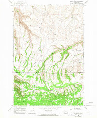
1965 Map of Poisel Butte SW
USGS Topo · Published 1966About this map
The Yakima Indian Reservation occupies the southern half of this mid-1960s survey, defined by the Reservation Boundary that separates it from the northern reaches of the quadrangle. This landscape is characterized by a network of drainage systems and high plateaus, such as The Island, which sits between the branching paths of Mule Creek and Dry Creek. The area is deeply dissected by drainages like Shinando Canyon, where the Shinando Canyon Road provides access through the rugged breaks. Genealogists and local historians will find the Onepennee Cem near the eastern boundary, a notable site of cultural importance within this mountainous terrain. The map also records the utilitarian infrastructure of the era, including the So Happy Road and Pine Springs Road, alongside numerous water sources such as Pine Spring and Rock Spring.
Find a feature on this map
19 named features on this map. Tap any name to fly to it.
Don’t see what you’re looking for? This feature index may not catch every label — zoom into the map to look around manually.
Map Details
Editions of this 1965 Poisel Butte SW Map
This is the sole edition of this map. No revisions or reprints were ever made.
Other maps of this area

1910 · Zillah
USGS Topo · 1:125,000

1916 · Arlington
USGS Topo · 1:125,000

1937 · White Swan
USGS Topo · 1:125,000

1950 · Yakima
USGS Topo · 1:250,000

1953 · The Dalles
USGS Topo · 1:250,000

1956 · The Dalles
USGS Topo · 1:250,000

1957 · The Dalles
USGS Topo · 1:250,000

1957 · Satus Pass
USGS Topo · 1:62,500

1958 · Yakima
USGS Topo · 1:250,000

1961 · Yakima
USGS Topo · 1:250,000