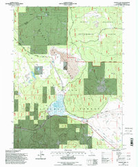
1995 Map of Poison Lake
USGS Topo · Published 1998About this map
Poison Lake and the volcanic landscape of Poison Butte dominate this section of the Lassen National Forest during the mid-1990s. The region is defined by forestry research and land management, centered around the Blacks Mountain Experimental Forest and the State Game Refuge. Evidence of industrial history is visible in the Old Railroad Grade that winds through the northern timberlands, while several Cinder Pits and a Quarry suggest active resource extraction near the volcanic peaks. The presence of Longs Cabin and remote water sources like Robbers Spring and Patterson Well highlights the sparse, utilitarian nature of human settlement in this high-elevation basin. The landscape is further marked by modern utilities, including a single wooden pole power line following the Pittville Road.
Find a feature on this map
26 named features on this map. Tap any name to fly to it.
Don’t see what you’re looking for? This feature index may not catch every label — zoom into the map to look around manually.
Map Details
Editions of this 1995 Poison Lake Map
This is the sole edition of this map. No revisions or reprints were ever made.
Other maps of this area

1886 · Lassen Peak
USGS Topo · 1:250,000

1892 · Lassen Peak
USGS Topo · 1:250,000

1894 · Lassen Peak
USGS Topo · 1:250,000

1939 · Halls Flat
USGS Topo · 1:125,000

1955 · Westwood
USGS Topo · 1:250,000

1956 · Harvey Mtn
USGS Topo · 1:62,500

1957 · Prospect Peak
USGS Topo · 1:62,500

1957 · Little Valley
USGS Topo · 1:62,500

1957 · Jellico
USGS Topo · 1:62,500

1958 · Westwood
USGS Topo · 1:250,000