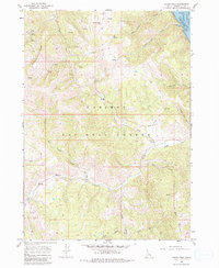
1966 Map of Poker Peak
USGS Topo · Published 1980About this map
Caribou National Forest and Targhee National Forest converge in this high-altitude landscape of Bonneville County, dominated by the prominent summit of Poker Peak. The mid-1960s topography reveals a remote interior defined by seasonal drainage and timbered ridges, where transport was limited to a network of established pack and jeep trails. In the northeast corner, the Snake River Palisades Res marks a significant hydrological boundary, with underwater contours provided by the U.S. Bureau of Reclamation. Local landmarks such as Bald Mtn Guard Sta and Jensen Meadow suggest the area's importance for forest management and grazing. The complex drainage system includes McCoy Creek, Sulphur Bar Creek, and the headwaters of West Fork Comb Creek, which cut through the steep terrain between Chicken Ridge and Black Mountain.
Find a feature on this map
24 named features on this map. Tap any name to fly to it.
Don’t see what you’re looking for? This feature index may not catch every label — zoom into the map to look around manually.
Map Details
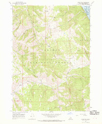
Editions of this 1966 Poker Peak Map
2 editions found
Other maps of this area

1932 · Irwin
USGS Topo · 1:96,000

1935 · Irwin
USGS Topo · 1:125,000

1955 · Driggs
USGS Topo · 1:250,000

1958 · Driggs
USGS Topo · 1:250,000

1962 · Driggs
USGS Topo · 1:250,000
1966 · Alpine
USGS Topo · 1:24,000

1966 · Big Elk Mtn
USGS Topo · 1:24,000
1966 · Tincup Mtn
USGS Topo · 1:24,000
1966 · Etna
USGS Topo · 1:24,000
1966 · Red Ridge
USGS Topo · 1:24,000