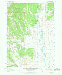
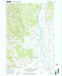
1966 Map of Etna
USGS Topo · Published 1969About this map
Star Valley dominates this 1960s landscape, where the meandering Salt River defines the border between Idaho and Wyoming. The settlement of Etna serves as the primary hub for this agricultural and timber region, situated near the western edge of the Salt River Range. To the west, the steep elevations of the Caribou National Forest are marked by a network of drainage systems like Jackknife Creek and Raymond Creek, alongside a series of specialized routes including the Mountain Trail, Pack Trail, and Jeep Trail. Water management is central to the valley's economy, evidenced by the East Side Canal, several unnamed Ditch segments, and a Powerplant located near the northern border. Recreational and logistical features like Tincup Campground and a Gaging Station reflect the dual use of the land for federal forest management and local ranching during the mid-20th century.
Find a feature on this map
35 named features on this map. Tap any name to fly to it.
Don’t see what you’re looking for? This feature index may not catch every label — zoom into the map to look around manually.
Map Details
Editions of this 1966 Etna Map
2 editions found
Other maps of this area

1915 · Freedom
USGS Topo · 1:62,500

1921 · Afton
USGS Topo · 1:125,000

1931 · Jackson
USGS Topo · 1:125,000

1932 · Irwin
USGS Topo · 1:96,000

1935 · Irwin
USGS Topo · 1:125,000

1935 · Jackson
USGS Topo · 1:125,000

1955 · Driggs
USGS Topo · 1:250,000

1955 · Preston
USGS Topo · 1:250,000

1958 · Driggs
USGS Topo · 1:250,000

1958 · Preston
USGS Topo · 1:250,000