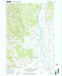
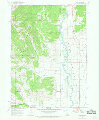
1966 Map of Etna
USGS Topo · Published 1979About this map
Salt River meanders across the Idaho-Wyoming border in this mid-1960s survey, marking the agricultural heart of the Salt Lake Valley. The settlement of Etna sits at the base of the high timberlands, where irrigation features like the Baker Ditch and East Side Canal define the local water management essential for valley ranching. The landscape transitions sharply from the flat river bottom to the dense reaches of the Caribou National Forest to the west, which is accessed via the Black Rock Trail and several other pack routes.
Find a feature on this map
36 named features on this map. Tap any name to fly to it.
Don’t see what you’re looking for? This feature index may not catch every label — zoom into the map to look around manually.
Map Details
Editions of this 1966 Etna Map
2 editions found
Other maps of this area

1915 · Freedom
USGS Topo · 1:62,500

1921 · Afton
USGS Topo · 1:125,000

1931 · Jackson
USGS Topo · 1:125,000

1932 · Irwin
USGS Topo · 1:96,000

1935 · Irwin
USGS Topo · 1:125,000

1935 · Jackson
USGS Topo · 1:125,000

1955 · Driggs
USGS Topo · 1:250,000

1955 · Preston
USGS Topo · 1:250,000

1958 · Driggs
USGS Topo · 1:250,000

1958 · Preston
USGS Topo · 1:250,000