1982 Map of Polacca
USGS Topo · Published 1983About this map
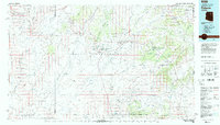
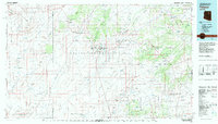
The ancient mesas of the Hopi Indian Reservation define this high desert landscape, which reaches across the borders of Coconino and Navajo counties. Centered on the unique settlement patterns of First Mesa, Second Mesa, and Third Mesa, the map documents established villages including Old Oraibi, Hotevilla, and Walpi. These communities are oriented around the vertical geography of the land, connected by the paths of Dinnebito Wash and Oraibi Wash. To the east, the administrative and social hub at Keams Canyon sits within the canyon walls near Sunlight Mission. To the north and south, the terrain shifts into the Coal Mine Mesa and the volcanic landscape of the Hopi Buttes, while isolated outposts like Polacca and Wepo Village mark the intersection of traditional land use and modern infrastructure like the Landing Strip.
Find a feature on this map
129 named features on this map. Tap any name to fly to it.
Don’t see what you’re looking for? This feature index may not catch every label — zoom into the map to look around manually.
Map Details
Editions of this 1982 Polacca Map
2 editions found
Other maps of this area

1883 · Marsh Pass
USGS Topo · 1:250,000

1883 · Tusayan
USGS Topo · 1:250,000

1886 · Tusayan
USGS Topo · 1:250,000

1886 · Fort Defiance
USGS Topo · 1:250,000

1886 · San Francisco Mtns
USGS Topo · 1:250,000

1886 · Echo Cliffs
USGS Topo · 1:250,000

1891 · San Francisco Mtns
USGS Topo · 1:250,000

1891 · Echo Cliffs
USGS Topo · 1:250,000

1892 · Fort Defiance
USGS Topo · 1:250,000

1892 · Marsh Pass
USGS Topo · 1:250,000