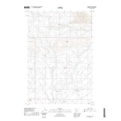
2020 Map of Poland Butte
USGS Topo · Published 2020About this map
Poland Butte and Oak Hill rise above a landscape defined by an intricate network of drainages and Bureau of Indian Affairs access roads. This 2020 survey of the Yakima County area highlights the central presence of Cedar Valley, where the terrain begins to transition from the higher elevations of the Mike Coon Hillside toward the southern flats. The map documents vital water sources including Shamrock Spring and Lyon Spring, alongside the complex confluence of White Cr, its western fork, and Tepee Cr. The presence of several BIA routes, such as Bia RD 175 and Bia RD 195, illustrates the managed access within these tribal lands. To the north, the S Fork Toppenish Cr and Toppenish Cr carve through the topography, joined by smaller tributaries like White Deer Cr and Brush Cr, showing the hydrology that sustains this high-country environment.
Find a feature on this map
31 named features on this map. Tap any name to fly to it.
Don’t see what you’re looking for? This feature index may not catch every label — zoom into the map to look around manually.
Map Details
Editions of this 2020 Poland Butte Map
This is the sole edition of this map. No revisions or reprints were ever made.
Other maps of this area

1904 · Mount Adams
USGS Topo · 1:125,000

1907 · Mount Adams
USGS Topo · 1:125,000

1937 · White Swan
USGS Topo · 1:125,000

1950 · Yakima
USGS Topo · 1:250,000
1957 · Willy Dick Canyon
USGS Topo · 1:24,000

1958 · Fort Simcoe
USGS Topo · 1:62,500

1958 · Yakima
USGS Topo · 1:250,000

1961 · Yakima
USGS Topo · 1:250,000
1965 · Hagerty Butte
USGS Topo · 1:24,000
1965 · Mc Kays Butte
USGS Topo · 1:24,000