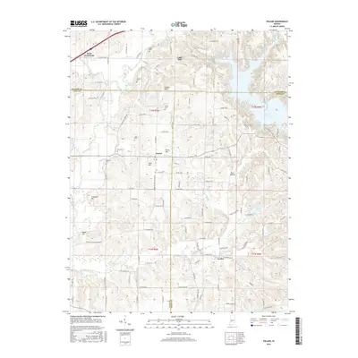
2016 Map of Poland
USGS Topo · Published 2016About this map
Poland and Jordan anchor this interior Indiana landscape, where the borders of Putnam, Clay, and Owen counties converge. The drainage of the Eel River and the expansive Cagles Mill Lake dominate the terrain, creating a complex network of waterways including Mill Creek, Jordan Cr, and Slate Run. For those tracing local families, the map is densely marked with family-named burial grounds such as Raab Cem, Grable Cem, and Ahlemeyer Cem, reflecting the deep-rooted settlement of the area.
Find a feature on this map
117 named features on this map. Tap any name to fly to it.
Don’t see what you’re looking for? This feature index may not catch every label — zoom into the map to look around manually.
Map Details
Editions of this 2016 Poland Map
This is the sole edition of this map. No revisions or reprints were ever made.
Other maps of this area

1908 · Clay City
USGS Topo · 1:48,000

1910 · Clay City
USGS Topo · 1:62,500

1950 · Brazil East
USGS Topo · 1:24,000

1952 · Reelsville
USGS Topo · 1:24,000

1953 · Indianapolis
USGS Topo · 1:250,000

1956 · Indianapolis
USGS Topo · 1:250,000

1956 · Cloverdale
USGS Topo · 1:24,000

1956 · Cataract
USGS Topo · 1:24,000

1956 · Patricksburg
USGS Topo · 1:24,000
1956 · Spencer
USGS Topo · 1:24,000