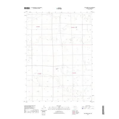
2017 Map of Pole Creek Valley
USGS Topo · Published 2017About this map
Niobrara River flows across the northern edge of this high plains landscape, while the namesake Pole Creek Valley occupies the central reaches of the map. This area of Cherry County is characterized by the intricate drainage of Pole Cr, which winds through a complex network of wetlands and small water bodies that dot the terrain. The northern portion features the expansive Lavaca Flats, an area where the flat topography meets the river system. The map provides a detailed view of the Public Land Survey System divisions, including t32n r40w and t31n r39w, showing the rectilinear property boundaries that defined settlement patterns in this remote section of the Nebraska Sandhills.
Find a feature on this map
8 named features on this map. Tap any name to fly to it.
Don’t see what you’re looking for? This feature index may not catch every label — zoom into the map to look around manually.
Map Details
Editions of this 2017 Pole Creek Valley Map
This is the sole edition of this map. No revisions or reprints were ever made.
Other maps of this area

1950 · Irwin
USGS Topo · 1:62,500

1951 · Irwin
USGS Topo · 1:62,500

1951 · Gypsy Valley
USGS Topo · 1:62,500

1955 · Alliance
USGS Topo · 1:250,000

1957 · Alliance
USGS Topo · 1:250,000

1957 · Valentine
USGS Topo · 1:250,000

1958 · Alliance
USGS Topo · 1:250,000

1959 · Valentine
USGS Topo · 1:250,000
1969 · Gordon SE
USGS Topo · 1:24,000
1969 · Rushville 4 NE
USGS Topo · 1:24,000