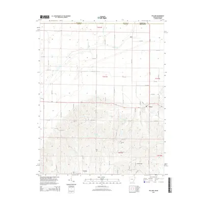
2014 Map of Pollard
USGS Topo · Published 2014About this map
Crowleys Ridge rises above the alluvial landscape in this northeast corner of Arkansas, creating a distinct topographical divide south of the Missouri state line. While the northern half of the map is dominated by the geometric drainage patterns of Ditch Number 17, Ditch Number 6, and Ditch Number 5, the southern section transitions into the rising elevations where the town of Pollard and the community of Crockett are situated. This geographic shift from low-lying wetlands like Fish Trap Slough to higher ground reflects the historic settlement patterns of Clay County. Genealogists will find a series of family-named burial sites across the ridge, including Crockett Cem, Rogers Cem, Cummings Cem, and Hardin Cem. The presence of the Ark-Mo Airport near the border highlights the intersection of local aviation with the rural agricultural economy.
Find a feature on this map
71 named features on this map. Tap any name to fly to it.
Don’t see what you’re looking for? This feature index may not catch every label — zoom into the map to look around manually.
Map Details
Editions of this 2014 Pollard Map
This is the sole edition of this map. No revisions or reprints were ever made.
Other maps of this area

1935 · Rector
USGS Topo · 1:62,500

1935 · Harviell
USGS Topo · 1:62,500

1940 · Valley Ridge
USGS Topo · 1:62,500

1940 · Piggott
USGS Topo · 1:62,500

1956 · Valley Ridge
USGS Topo · 1:62,500

1956 · Piggott
USGS Topo · 1:62,500

1957 · Poplar Bluff
USGS Topo · 1:250,000

1958 · Rector
USGS Topo · 1:62,500

1959 · Poplar Bluff
USGS Topo · 1:250,000
1960 · Rector
USGS Topo · 1:62,500