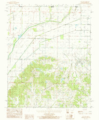
1984 Map of Pollard
USGS Topo · Published 1984About this map
Pollard sits on the southern edge of a landscape defined by the intersection of Crowley's Ridge and the reclaimed lowlands of the Mississippi embayment. This 1984 survey reveals an intricate network of drainage engineering, most notably the Little Cache River Ditch, which cuts a straight path across the terrain to manage the flow of the local river system. The presence of Trap Slough further highlights the transition from the elevated, timbered hills to the lower bottomlands. Situated along the Butler Co Clay Co line, the map documents the rural boundary between Arkansas and Missouri. The settlement pattern here reflects the agricultural development of the late 20th century, where land use is strictly divided between the wooded slopes and the gridded, drained fields of the valley floor.
Find a feature on this map
4 named features on this map. Tap any name to fly to it.
Don’t see what you’re looking for? This feature index may not catch every label — zoom into the map to look around manually.
Map Details
Editions of this 1984 Pollard Map
This is the sole edition of this map. No revisions or reprints were ever made.
Other maps of this area

1935 · Rector
USGS Topo · 1:62,500

1935 · Harviell
USGS Topo · 1:62,500

1940 · Valley Ridge
USGS Topo · 1:62,500

1940 · Piggott
USGS Topo · 1:62,500

1956 · Valley Ridge
USGS Topo · 1:62,500

1956 · Piggott
USGS Topo · 1:62,500

1957 · Poplar Bluff
USGS Topo · 1:250,000

1958 · Rector
USGS Topo · 1:62,500

1959 · Poplar Bluff
USGS Topo · 1:250,000
1960 · Rector
USGS Topo · 1:62,500