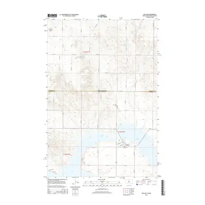
2015 Map of Pollock
USGS Topo · Published 2015About this map
The town of Pollock sits at a geographic crossroads along the shores of Lake Pocasse and the expansive Lake Oahe. This 2015 survey illustrates a landscape defined by the intersection of the North Dakota and South Dakota state line and the border between Emmons and Campbell counties. The town's layout is closely tied to the water, with Lake View Drive and Oahe Street providing access to the reservoir's edge. To the north, the terrain transitions into a grid of agricultural section lines, including 100th Street SE and 101st Street SE, punctuated by the Vander Wal Private Airport. Local heritage is preserved at Spring Valley Cemetery and LaGrace Cemetery, while the winding course of Decker Creek feeds into the larger reservoir system, highlighting the area's significance for water management and regional transit.
Find a feature on this map
38 named features on this map. Tap any name to fly to it.
Don’t see what you’re looking for? This feature index may not catch every label — zoom into the map to look around manually.
Map Details
Editions of this 2015 Pollock Map
This is the sole edition of this map. No revisions or reprints were ever made.
Other maps of this area

1953 · McIntosh
USGS Topo · 1:250,000

1954 · Bismarck
USGS Topo · 1:250,000

1958 · Bismarck
USGS Topo · 1:250,000

1958 · McIntosh
USGS Topo · 1:250,000

1965 · Herreid NW
USGS Topo · 1:24,000

1965 · Herreid SW
USGS Topo · 1:24,000

1965 · Pollock SE
USGS Topo · 1:24,000

1965 · Pollock
USGS Topo · 1:24,000

1966 · Kenel
USGS Topo · 1:24,000

1966 · Pollock NW
USGS Topo · 1:24,000