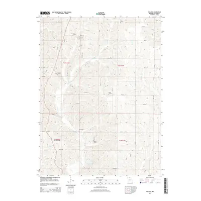
2015 Map of Pollock
USGS Topo · Published 2015About this map
The northern Sullivan County settlement of Pollock serves as a focal point for this rural landscape, situated near the confluence of local township lines. The terrain is defined by the winding course of E Locust Cr and W Yellow Cr, which carve through the countryside alongside smaller tributaries like Elmwood Br. Further south, the community of Boynton and the locality of Jacksonville mark the transition toward more open acreage, while Sears Community Lake provides a distinct water feature in the lower quadrant. This map is particularly valuable for genealogists, as it preserves the locations of several family-named burial grounds, including Scobee Cemetery, Pollock Cemetery, Campbell Cemetery, Holiday Cemetery, and Hamilton Cemetery, which remain important landmarks of local family heritage in this agricultural region.
Find a feature on this map
53 named features on this map. Tap any name to fly to it.
Don’t see what you’re looking for? This feature index may not catch every label — zoom into the map to look around manually.
Map Details
Editions of this 2015 Pollock Map
This is the sole edition of this map. No revisions or reprints were ever made.
Other maps of this area

1912 · Green City
USGS Topo · 1:62,500

1914 · Green City
USGS Topo · 1:62,500

1954 · Centerville
USGS Topo · 1:250,000

1957 · Centerville
USGS Topo · 1:250,000

1958 · Centerville
USGS Topo · 1:250,000
1963 · Mystic
USGS Topo · 1:24,000

1964 · Pollock NW
USGS Topo · 1:24,000

1964 · Milan West
USGS Topo · 1:24,000
1964 · Milan East
USGS Topo · 1:24,000

1964 · Unionville West
USGS Topo · 1:24,000