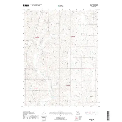
2017 Map of Pollock
USGS Topo · Published 2017About this map
The northern Sullivan County settlements of Pollock and Boynton anchor this rural landscape, which is defined by a dense network of family-named cemeteries and narrow watercourses. Established burial grounds such as Pollock Cem, Scobee Cem, Campbell Cem, and Hamilton Cem are scattered across the terrain, reflecting the long-standing community ties in this part of Missouri. The topography is shaped by the drainage patterns of E Locust Cr and W Yellow Cr, which carve through the countryside near local roads like Kentucky Rd and Lonesome Rd. In the southern portion of the quadrangle, Sears Community Lake and the Elmwood Br provide notable water features amidst the agricultural land. This survey provides a clear view of the rural infrastructure, from the small clusters of buildings in the primary townships to the isolated Holiday Cem and Gilbert Cem in the northern hills.
Find a feature on this map
64 named features on this map. Tap any name to fly to it.
Don’t see what you’re looking for? This feature index may not catch every label — zoom into the map to look around manually.
Map Details
Editions of this 2017 Pollock Map
This is the sole edition of this map. No revisions or reprints were ever made.
Other maps of this area

1912 · Green City
USGS Topo · 1:62,500

1914 · Green City
USGS Topo · 1:62,500

1954 · Centerville
USGS Topo · 1:250,000

1957 · Centerville
USGS Topo · 1:250,000

1958 · Centerville
USGS Topo · 1:250,000
1963 · Mystic
USGS Topo · 1:24,000

1964 · Pollock NW
USGS Topo · 1:24,000

1964 · Milan West
USGS Topo · 1:24,000
1964 · Milan East
USGS Topo · 1:24,000

1964 · Unionville West
USGS Topo · 1:24,000