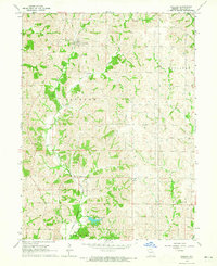
1964 Map of Pollock
USGS Topo · Published 1965About this map
The Chicago Burlington and Quincy railroad defines the transportation corridor of this mid-century Sullivan County landscape, tracing a route through the settlement of Pollock and south towards Boynton. This 1964 field-checked survey reveals a rural society structured around small township divisions like Jackson, Buchanan, Polk, and Penn. The terrain is deeply carved by the branching systems of East Locust Creek, Spring Creek, and West Yellow Creek, which created the complex ridges and valleys typical of north-central Missouri. Local genealogy is well-documented through numerous family-named landmarks and rural congregations, including Scobee Cem, Hamilton Cem, and the Mt Zion Ch. To the south, Sears Community Lake serves as a prominent water feature in an otherwise strictly agricultural and wooded region, providing a rare point of engineered recreation within the natural drainage of the hills.
Find a feature on this map
21 named features on this map. Tap any name to fly to it.
Don’t see what you’re looking for? This feature index may not catch every label — zoom into the map to look around manually.
Map Details
Editions of this 1964 Pollock Map
This is the sole edition of this map. No revisions or reprints were ever made.
Other maps of this area

1912 · Green City
USGS Topo · 1:62,500

1914 · Green City
USGS Topo · 1:62,500

1954 · Centerville
USGS Topo · 1:250,000

1957 · Centerville
USGS Topo · 1:250,000

1958 · Centerville
USGS Topo · 1:250,000
1963 · Mystic
USGS Topo · 1:24,000

1964 · Pollock NW
USGS Topo · 1:24,000

1964 · Milan West
USGS Topo · 1:24,000
1964 · Milan East
USGS Topo · 1:24,000

1964 · Unionville West
USGS Topo · 1:24,000