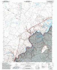
1994 Map of Pollocksville
USGS Topo · Published 1997About this map
The Trent River meanders through this landscape, defining the boundary between established settlements and the dense timberlands of the Croatan National Forest. In this 1990s revision of mid-century surveys, the town of Pollocksville serves as a local hub, anchored by the Pollocksville Elem Sch. The rural character of the region is traced through family-named junctions such as Simmons Corner, Jones Corner, and Tenmile Fork, which connect small communities like Hargett and Oak Grove to the larger riverfront developments at Trent Woods and River Bend.
Find a feature on this map
35 named features on this map. Tap any name to fly to it.
Don’t see what you’re looking for? This feature index may not catch every label — zoom into the map to look around manually.
Map Details
Editions of this 1994 Pollocksville Map
2 editions found
Other maps of this area

1901 · New Bern
USGS Topo · 1:62,500

1903 · New Bern
USGS Topo · 1:62,500

1903 · Trent River
USGS Topo · 1:62,500

1904 · Trent River
USGS Topo · 1:62,500

1942 · Maysville
USGS Topo · 1:62,500

1943 · Jacksonville
USGS Topo · 1:62,500

1948 · Maysville
USGS Topo · 1:62,500

1950 · Pollocksville
USGS Topo · 1:24,000

1950 · New Bern
USGS Topo · 1:24,000

1953 · Rocky Mount
USGS Topo · 1:250,000