
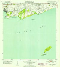
1947 Map of Ponce NO
USGS Topo · Published 1947About this map
Agricultural haciendas define the mid-century landscape north of Ponce, where the terrain transitions into the steep interior highlands. Major holdings including Hacienda Anón, Hacienda Paraíso, and Hacienda Monserrate are situated along the river valleys, reflecting the historical importance of the island’s coffee and sugar economies. This 1947 survey captures the settlement pattern before significant urban expansion, highlighting concentrated residential areas like Poblado Real Abajo and Poblado Cerrillos.
Find a feature on this map
21 named features on this map. Tap any name to fly to it.
Don’t see what you’re looking for? This feature index may not catch every label — zoom into the map to look around manually.
Map Details
Editions of this 1947 Ponce NO Map
This is the sole edition of this map. No revisions or reprints were ever made.
Historical Maps of Maragüez Through Time
19 maps found

1945 Playa De Ponce
Ponce Municipio, PR

1946 Punta Cuchara
Ponce Municipio, PR

1947 Adjuntas SE
Ponce Municipio, PR

1947 Jayuya SO
Ponce Municipio, PR

1947 Penuelas NE
Ponce Municipio, PR

1947 Penuelas SE
Ponce Municipio, PR

1947 Playa De Ponce NO
Ponce Municipio, PR
1947 Ponce NO
Ponce Municipio, PR

1947 Ponce SO
Ponce Municipio, PR

1947 Punta Gughara NE
Ponce Municipio, PR
1952 Playa De Ponce
Ponce Municipio, PR

1952 Punta Cuchara
Ponce Municipio, PR

1958 Playa De Ponce
Ponce Municipio, PR

1958 Punta Cucharas
Ponce Municipio, PR

1962 Playa De Ponce
Ponce Municipio, PR
1962 Punta Cucharas
Ponce Municipio, PR
1970 Playa De Ponce
Ponce Municipio, PR

2024 Playa De Ponce
Ponce Municipio, PR

2024 Punta Cucharas
Ponce Municipio, PR