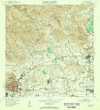
1952 Map of Ponce
USGS Topo · Published 1953About this map
The agricultural landscape of southern Puerto Rico is dominated by a complex network of estates and sugar production facilities at the middle of the century. Central Mercedita stands as a primary industrial hub, connected to the coastal plains by the American RR of Puerto Rico and the Ponce and Guayama RR. The terrain transitions from the dense urban barrios of Ponce and Alhambra into the steep foothills of the Cordillera Central, where numerous named haciendas such as Hacienda Arbona, Hacienda Usera, and Hacienda Monserrate are situated along the river valleys of the Río Cerrillos and Río Inabon. Water management for this productive region is evident in the string of numbered reservoirs, Lago No 1 through Lago No 5, and the larger Lago Guayabal to the northeast. These features illustrate the intensive relationship between the island's interior watersheds and the industrial sugar economy that defined the era.
Find a feature on this map
141 named features on this map. Tap any name to fly to it.
Don’t see what you’re looking for? This feature index may not catch every label — zoom into the map to look around manually.
Map Details
Editions of this 1952 Ponce Map
2 editions found
Other maps of this area

1944 · Santa Isabel
USGS Topo · 1:30,000

1945 · Playa De Ponce
USGS Topo · 1:30,000

1945 · Ponce
USGS Topo · 1:30,000

1945 · Rio Descalabrado
USGS Topo · 1:30,000

1946 · Punta Cuchara
USGS Topo · 1:30,000

1946 · Jayuya
USGS Topo · 1:30,000

1946 · Orocovis
USGS Topo · 1:30,000

1946 · Penuelas
USGS Topo · 1:30,000

1946 · Adjuntas
USGS Topo · 1:30,000

1947 · Ponce NE
USGS Topo · 1:10,000