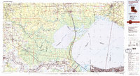
1983 Map of Ponchatoula
USGS Topo · Published 1984About this map
Lake Maurepas and Lake Pontchartrain dominate this 1980s landscape, illustrating the complex hydrology of the coastal lowlands between the Mississippi River and the growing Northshore communities. The map highlights critical water management features like the Bonnet Carre Spillway and the Amite River Diversion Canal, which manage floodwaters for the surrounding parishes. On the north side of the lakes, the towns of Hammond and Ponchatoula serve as inland hubs, with Southeastern Louisiana University established as a major regional landmark.
Find a feature on this map
128 named features on this map. Tap any name to fly to it.
Don’t see what you’re looking for? This feature index may not catch every label — zoom into the map to look around manually.
Map Details
Editions of this 1983 Ponchatoula Map
2 editions found
Other maps of this area

1891 · Hahnville
USGS Topo · 1:62,500

1891 · Spanish Fort
USGS Topo · 1:62,500

1891 · New Orleans
USGS Topo · 1:62,500

1892 · Lac Des Allemands
USGS Topo · 1:62,500

1892 · Chef Menteur
USGS Topo · 1:62,500

1892 · Mount Airy
USGS Topo · 1:62,500

1892 · Bonnet Carre
USGS Topo · 1:62,500

1892 · Donaldsonville
USGS Topo · 1:62,500

1892 · St. Bernard
USGS Topo · 1:62,500

1892 · Thibodaux
USGS Topo · 1:62,500