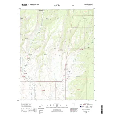
2020 Map of Ponderosa
USGS Topo · Published 2020About this map
Jemez Springs and the village of Ponderosa anchor this high-altitude landscape within the Santa Fe National Forest. The geography is defined by a series of dramatic mesas and canyons, where the Jemez River and Rio Guadalupe have carved deep paths through the Jemez Mountains. Historical water management is evident in the Cañones Communities Ditch, a feature reflecting the area's long-standing reliance on communal irrigation systems. Significant landforms like Virgin Mesa, San Juan Mesa, and Guadalupita Mesa dominate the terrain, separated by steep drainages such as Virgin Canyon and Paliza Canyon. Along the southern reaches, the map tracks Vallecito Cr and secondary routes like Indian Svc Rte 821, highlighting the area's transition between forest land and tribal service territories.
Find a feature on this map
38 named features on this map. Tap any name to fly to it.
Don’t see what you’re looking for? This feature index may not catch every label — zoom into the map to look around manually.
Map Details
Editions of this 2020 Ponderosa Map
This is the sole edition of this map. No revisions or reprints were ever made.
Other maps of this area

1890 · Jemes
USGS Topo · 1:125,000

1892 · Jemes
USGS Topo · 1:125,000

1937 · Jemez Springs
USGS Topo · 1:48,000

1939 · La Ventana
USGS Topo · 1:62,500

1939 · San Ysidro
USGS Topo · 1:62,500

1943 · San Ysidro
USGS Topo · 1:62,500

1943 · Jemez
USGS Topo · 1:62,500

1943 · La Ventana
USGS Topo · 1:62,500

1944 · Jemez Springs
USGS Topo · 1:62,500

1952 · Jemez Springs
USGS Topo · 1:62,500