Loading...
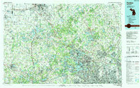
Loading map...1985 Map of Pontiac
USGS Topo · Published 1989About this map
Pontiac and the surrounding lake country of Oakland Co are defined by a complex mosaic of glacial kettle lakes and expanding suburban centers in the mid-1980s. Large water bodies like Cass Lake, Orchard Lake, and Pontiac Lake anchor the landscape, while the regional transportation network is dominated by the Grand Trunk Western RR and the Chesapeake and Ohio RR. The map illustrates the significant investment in public lands during this era, with vast tracts dedicated to the Holly State Recreation Area and Highland State Recreation Area.
Find a feature on this map
324 named features on this map. Tap any name to fly to it.
Don’t see what you’re looking for? This feature index may not catch every label — zoom into the map to look around manually.
Map Details
Date Portrayed1985
Date Published1989
PublisherU.S. Geological Survey
Map TypeTopographic
Scale1:100,000
Physical Dimensions38.4 x 24.1 inches
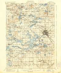
Editions of this 1985 Pontiac Map
2 editions found

Historical Maps of Sterling Heights Through Time
Featured Locations
Source Details
SourceU.S. Geological Survey
CopyrightPublic Domain