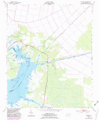
1951 Map of Ponzer
USGS Topo · Published 1983About this map
The Pungo River bisects this coastal landscape, where the marshy lowlands of Hyde County meet the open water. The settlement of Ponzer sits near the northern reaches, while Scranton anchors the southern banks along Scranton Creek. This map reveals a complex network of drainage and transportation, including the Intracoastal Waterway Pungo River-Alligator River Canal and the State Canal, reflecting the region's reliance on water-borne commerce and land reclamation.
Find a feature on this map
41 named features on this map. Tap any name to fly to it.
Don’t see what you’re looking for? This feature index may not catch every label — zoom into the map to look around manually.
Map Details
Editions of this 1951 Ponzer Map
3 editions found
Other maps of this area

1914 · Belhaven
USGS Topo · 1:48,000

1916 · Belhaven
USGS Topo · 1:62,500

1943 · Columbia
USGS Topo · 1:125,000

1943 · Plymouth
USGS Topo · 1:125,000

1951 · Pamlico Beach
USGS Topo · 1:24,000

1951 · Belhaven
USGS Topo · 1:24,000

1951 · Scranton
USGS Topo · 1:24,000

1951 · Swanquarter
USGS Topo · 1:24,000

1951 · Ponzer
USGS Topo · 1:24,000

1951 · New Lake SE
USGS Topo · 1:24,000