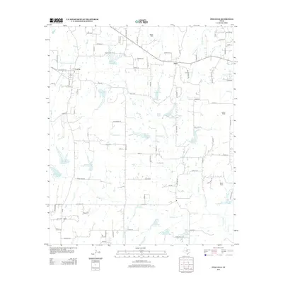
2012 Map of Poolville
USGS Topo · Published 2012About this map
Poolville and Agnes anchor this Parker County landscape, characterized by the winding path of the Clear Fork Trinity River and an extensive network of water management features. The area is dotted with numbered catchments, from Reservoir Number Three to Reservoir Number Fifteen, reflecting the region's managed agricultural and water resources. The terrain is punctuated by distinct high points such as Skeen Peak, Indian Knob, and Buck Knob, while the Toto Gas Field indicates the industrial utility of the land. Local history is preserved in sites like Erwin Cem and Dilbeck Cem, which sit alongside family-named roads such as Erwin Rd and Ross Ave. The intricate drainage system includes numerous creeks like Gourdneck Cr and Cottonwood Cr, which feed into the river system through the central corridor of the quadrangle.
Find a feature on this map
78 named features on this map. Tap any name to fly to it.
Don’t see what you’re looking for? This feature index may not catch every label — zoom into the map to look around manually.
Map Details
Editions of this 2012 Poolville Map
This is the sole edition of this map. No revisions or reprints were ever made.
Other maps of this area

1891 · Weatherford
USGS Topo · 1:125,000

1893 · Weatherford
USGS Topo · 1:125,000

1930 · Boyd
USGS Topo · 1:62,500

1932 · Springtown
USGS Topo · 1:62,500

1954 · Dallas
USGS Topo · 1:250,000

1954 · Sherman
USGS Topo · 1:250,000

1958 · Dallas
USGS Topo · 1:250,000

1958 · Sherman
USGS Topo · 1:250,000

1958 · Springtown
USGS Topo · 1:24,000
1959 · Lake Weatherford
USGS Topo · 1:24,000