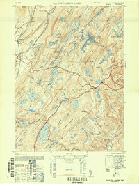
1947 Map of Popolopen Lake
USGS Topo · Published 1947About this map
Popolopen Lake and the West Point Military Reservation dominate this landscape, reflecting a region defined by tactical training grounds and massive protected parklands. The presence of the Forrest of Dean mine near Mine Lake points to the area's deep industrial roots, while the sprawling Palisades Interstate Park showcases the mid-century commitment to public recreation. Small residential clusters like Baileytown and Butsontown are tucked between massive peaks such as Bear Mountain and Blackcap Mountain. To the west, the settlements of Highland Mills and Central Valley sit along the creek valleys, contrasting with the high-elevation landmarks like the Perkins Memorial Observatory on the eastern ridges. The map captures a complex network of reservoirs including Lake Frederick and Queensboro Lake, essential for both the military post and surrounding communities.
Find a feature on this map
75 named features on this map. Tap any name to fly to it.
Don’t see what you’re looking for? This feature index may not catch every label — zoom into the map to look around manually.
Map Details
Editions of this 1947 Popolopen Lake Map
This is the sole edition of this map. No revisions or reprints were ever made.
Other maps of this area

1891 · Ramapo
USGS Topo · 1:62,500

1892 · West Point
USGS Topo · 1:62,500

1892 · Tarrytown
USGS Topo · 1:62,500

1893 · Tarrytown
USGS Topo · 1:62,500

1893 · Ramapo
USGS Topo · 1:62,500

1894 · West Point
USGS Topo · 1:62,500

1899 · West Point
USGS Topo · 1:62,500

1901 · West Point
USGS Topo · 1:62,500

1902 · Tarrytown
USGS Topo · 1:62,500

1902 · Schunemunk
USGS Topo · 1:62,500