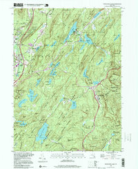
1994 Map of Popolopen Lake
USGS Topo · Published 1999About this map
US Military Academy West Point lands dominate the northern reaches of this terrain, where military training grounds like Camp Buckner and Camp Natural Bridge sit among the high ridges. The landscape is a complex network of conservation and education, with Harriman State Park and Bear Mountain State Park providing a backdrop for legacy trails including the Appalachian Trail and the Long Path. This area is defined by its deep basins and rocky summits, from Popolopen Lake to the heights of Bear Mtn.
Find a feature on this map
99 named features on this map. Tap any name to fly to it.
Don’t see what you’re looking for? This feature index may not catch every label — zoom into the map to look around manually.
Map Details
Editions of this 1994 Popolopen Lake Map
This is the sole edition of this map. No revisions or reprints were ever made.
Other maps of this area

1891 · Ramapo
USGS Topo · 1:62,500

1892 · West Point
USGS Topo · 1:62,500

1892 · Tarrytown
USGS Topo · 1:62,500

1893 · Tarrytown
USGS Topo · 1:62,500

1893 · Ramapo
USGS Topo · 1:62,500

1894 · West Point
USGS Topo · 1:62,500

1899 · West Point
USGS Topo · 1:62,500

1901 · West Point
USGS Topo · 1:62,500

1902 · Tarrytown
USGS Topo · 1:62,500

1902 · Schunemunk
USGS Topo · 1:62,500