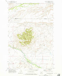
1972 Map of Porcupine Butte
USGS Topo · Published 1975About this map
Porcupine Butte dominates the center of this rangeland survey, its summit rising above a network of drainages along the border of Wheatland and Sweet Grass counties. The landscape is defined by the management of water in a semi-arid environment, evidenced by an extensive system of irrigation channels including the Tronrud Ditch, Hoyem Ditch, and Hart Parker Ditch. These human-made waterways divert flow from Sweet Grass Creek and its tributaries to support the surrounding ranchlands.
Find a feature on this map
21 named features on this map. Tap any name to fly to it.
Don’t see what you’re looking for? This feature index may not catch every label — zoom into the map to look around manually.
Map Details
Editions of this 1972 Porcupine Butte Map
This is the sole edition of this map. No revisions or reprints were ever made.
Other maps of this area

1886 · Little Belt Mts.
USGS Topo · 1:250,000

1889 · Big Snowy Mountain
USGS Topo · 1:250,000

1893 · Big Snowy Mountain
USGS Topo · 1:250,000

1894 · Little Belt Mts.
USGS Topo · 1:250,000

1897 · Little Belt Mts.
USGS Topo · 1:250,000

1898 · Little Belt Mts.
USGS Topo · 1:250,000

1902 · Little Belt Mts.
USGS Topo · 1:250,000

1948 · White Sulphur Springs
USGS Topo · 1:250,000

1954 · Roundup
USGS Topo · 1:250,000

1958 · Roundup
USGS Topo · 1:250,000