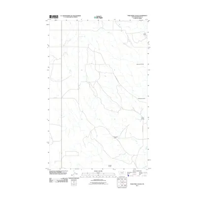
2011 Map of Porcupine Coulee
USGS Topo · Published 2011About this map
Porcupine Coulee winds through this section of Phillips County, Montana, carving through a landscape defined by an intricate network of drainage channels and remote ranch roads. In the early 21st century, the area remains dominated by its natural topography, where water sources like Split Shack Spring were vital for local livestock and land management. The map details the convergence of several major draws, including Rattlesnake Coulee and Poplar Coulee, which eventually feed toward larger regional watersheds. Travel across this high plains terrain is facilitated by unpaved routes such as Frenchman Creek Rd and Helmers Rd, reflecting the sparse but functional infrastructure required to navigate the coulee-scarred prairie. This survey offers a clear view of the hydrological patterns and named landmarks that orient residents and land users in a vast, open environment.
Find a feature on this map
8 named features on this map. Tap any name to fly to it.
Don’t see what you’re looking for? This feature index may not catch every label — zoom into the map to look around manually.
Map Details
Editions of this 2011 Porcupine Coulee Map
This is the sole edition of this map. No revisions or reprints were ever made.
Other maps of this area

1954 · Glasgow
USGS Topo · 1:250,000

1957 · Glasgow
USGS Topo · 1:250,000

1958 · Glasgow
USGS Topo · 1:250,000

1984 · Cole
USGS Topo · 1:24,000

1984 · Bjornberg Bridge
USGS Topo · 1:24,000

1984 · Double S Hill
USGS Topo · 1:24,000

1984 · Forks
USGS Topo · 1:24,000

1984 · Coulter Coulee
USGS Topo · 1:24,000

1984 · Dead Horse Coulee
USGS Topo · 1:24,000
1984 · Salsbery Reservoir
USGS Topo · 1:24,000