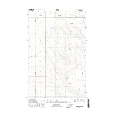
2017 Map of Porcupine Coulee
USGS Topo · Published 2017About this map
Split Shack Spring provides a rare point of water in this part of Phillips County, where the landscape is defined by the deep incisions of numerous seasonal drainage channels. The area is characterized by these distinct landforms, including Rattlesnake Coulee and Corral Coulee in the north, and Poplar Coulee further south. The map illustrates a remote grazing or ranching landscape where human presence is marked primarily by sparse rural routes like Turkey Track Rd and Frenchman Rd. The concentration of named drainages like Porcupine Coulee and Ash Coulee suggests a terrain where topography and the intermittent flow of water dictated the placement of roads and early ranching boundaries in the Big Sky Country.
Find a feature on this map
16 named features on this map. Tap any name to fly to it.
Don’t see what you’re looking for? This feature index may not catch every label — zoom into the map to look around manually.
Map Details
Editions of this 2017 Porcupine Coulee Map
This is the sole edition of this map. No revisions or reprints were ever made.
Other maps of this area

1954 · Glasgow
USGS Topo · 1:250,000

1957 · Glasgow
USGS Topo · 1:250,000

1958 · Glasgow
USGS Topo · 1:250,000

1984 · Cole
USGS Topo · 1:24,000

1984 · Bjornberg Bridge
USGS Topo · 1:24,000

1984 · Double S Hill
USGS Topo · 1:24,000

1984 · Forks
USGS Topo · 1:24,000

1984 · Coulter Coulee
USGS Topo · 1:24,000

1984 · Dead Horse Coulee
USGS Topo · 1:24,000
1984 · Salsbery Reservoir
USGS Topo · 1:24,000