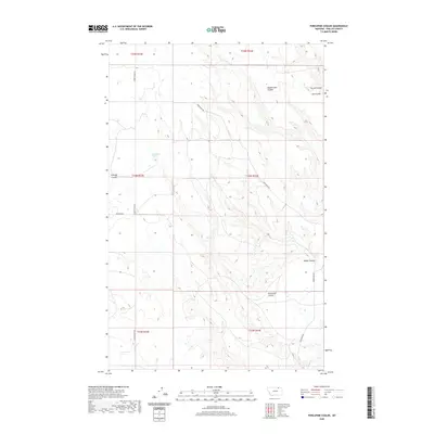
2020 Map of Porcupine Coulee
USGS Topo · Published 2020About this map
Split Shack Spring marks a rare water source in this high-plains landscape of Phillips County, where the terrain is defined by a complex network of seasonal drainages. The area is characterized by deeply incised features such as Prestige Coulee and Rattlesnake Coulee, which create a natural navigation system across the open range. Modern cattle ranching and land management are evident through the preservation of historic travel ways like Turkey Track Rd and Frenchman Rd, which follow the contours of the land between water sources. This 2020 survey illustrates how the northern Montana landscape remains oriented around these drainage systems, including Poplar Coulee and the primary Porcupine Coulee, which dictate the placement of local roads and property boundaries in this sparsely populated region.
Find a feature on this map
16 named features on this map. Tap any name to fly to it.
Don’t see what you’re looking for? This feature index may not catch every label — zoom into the map to look around manually.
Map Details
Editions of this 2020 Porcupine Coulee Map
This is the sole edition of this map. No revisions or reprints were ever made.
Other maps of this area

1954 · Glasgow
USGS Topo · 1:250,000

1957 · Glasgow
USGS Topo · 1:250,000

1958 · Glasgow
USGS Topo · 1:250,000

1984 · Cole
USGS Topo · 1:24,000

1984 · Bjornberg Bridge
USGS Topo · 1:24,000

1984 · Double S Hill
USGS Topo · 1:24,000

1984 · Forks
USGS Topo · 1:24,000

1984 · Coulter Coulee
USGS Topo · 1:24,000

1984 · Dead Horse Coulee
USGS Topo · 1:24,000
1984 · Salsbery Reservoir
USGS Topo · 1:24,000